On April 10, 2026, from a control room on the outskirts of Madrid, a pilot pressed a key and, more than six hundred kilometers away, a metal lid opened in the middle of the Extremadura forest.
A drone rose silently, turned its cameras toward the horizon, and began searching for plumes of smoke.
No one moved from Madrid. This is how T_Space was born, the first comprehensive commercial service of remotely piloted drones in Spain, and with it, perhaps, the most concrete version of what a truly smart city means.
The future of smart cities requires many drones
By: Gabriel E. Levy B.
Telefónica became the first telecommunications operator to offer drones as a turnkey service for companies and public administrations on that day.
The initiative is not only technological: it is a strategic commitment to turn the 5G network, data centers and artificial intelligence into the backbone of a new way of managing the territory.
In a European drone market that will reach 7,980 million dollars by 2030 and a global urban air mobility ecosystem valued at almost 29,200 million by the same date, Spain T_Space positioned as a continental laboratory for a technology that promises to redefine life in cities.
How T_Space, Telefónica’s aerial brain, works
T_Space is not a drone with a 5G connection.
It’s a complete ecosystem that integrates hardware, connectivity, data analytics, regulatory permissions, and human operation under one commercial roof.
The centre of all this machinery is Telefónica’s National Supervision and Operation Centre in Aravaca, Madrid, a complex that has been operating since 1997 and now extends its mission to digital airspace.
From there, with redundant power and connectivity, twelve professional pilots trained for almost a year control up to two drones simultaneously, receiving telemetry, live video and weather information in real time.
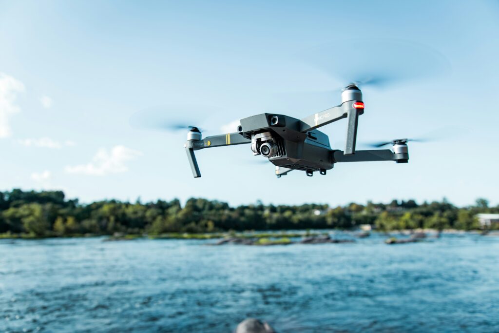
On the ground, the key piece is called Drone-in-a-Box: automated stations that act as autonomous hangars.
The drone lives there protected, recharges itself and, when it receives the order from Madrid, takes off without anyone touching it.
The devices, manufactured in Europe by Nokia Drone Networks, carry HD and infrared cameras, weigh up to twenty kilograms, fly at fifty or sixty kilometers per hour and last about thirty minutes in the air.
With Telefónica’s 5G network, which covers about ninety-five percent of the Spanish population, they can operate in BVLOS mode (beyond the pilot’s line of sight) with a potential range of more than five hundred kilometers.
The system’s architecture rests on five pillars: 5G connectivity with network segmentation to prioritize drone communications; a network of mini-data centres distributed throughout Spain that process images with artificial intelligence in real time; the Open Gateway APIs, a standard promoted by the GSMA that provides dynamic data on air connectivity, population density under the drone route and quality of service; a Dimetor/AirborneRF flight planning platform that assesses risks according to the SORA methodology required by European regulation; and the human factor: the twelve CNSO pilots who supervise each mission from the beginning to landing. Borja Ochoa, president of Telefónica Spain, sums it up like this: it is an «end-to-end model in which hardware, connectivity, analytics, permissions, platform and operation are integrated».
The service is marketed in two modalities. The first, Flight as a Service, is designed for customers who already have their own drones and only want to outsource remote piloting. The second, Drone as a Service, is a comprehensive solution that includes hardware, specific sensors, information processing and complete aerial operation. In both cases, Telefónica assumes the management of flight permits, analysis with artificial intelligence and maintenance of the equipment.
Cuacos de Yuste, the first real flight against fires
The operational baptism of T_Space took place in Cuacos de Yuste, a municipality of Cáceres surrounded by Mediterranean forest, in collaboration with the Junta de Extremadura, which became the first public administration to use the service. The use case is as simple to explain as it is urgent in real terms: the prevention of forest fires in one of the most vulnerable regions of the Iberian Peninsula.
When the forest firefighters suspect a column of smoke, they contact the T_Space pilots in Madrid. In a few minutes, the Drone-in-a-Box station in Cuacos de Yuste opens, the drone takes off and heads for the heat source. Thermal cameras transmit images in real time via 5G to emergency teams, who decide whether to move ground resources or maintain aerial surveillance. An operation that previously required pilots and teams to be deployed to the field is now being carried out from six hundred kilometres away with an almost immediate response.
This first case opens the door to a wider catalogue of applications: surveillance of critical infrastructures, inspection of electrical and industrial networks, inventory logistics in warehouses by autonomous scanning of QR codes and creation of air corridors for the transport of medical supplies between hospitals. Sergio Sánchez, Director of Operations, Network and IT at Telefónica Spain, stresses that the capillarity of the network allows it to operate «both in urban points with a high demand for connectivity and in rural areas that are not reached by other operators».
European U-Space, the regulatory framework that makes it possible
No commercial drone flies over a European city legally without a regulatory scaffolding that has taken almost a decade to build. The concept that articulates everything is U-Space, a set of digital services and procedures designed so that a large number of drones can access airspace in a safe and orderly way, coexisting with manned aviation. The European Commission understands it as a transition from a system focused on pilots and human controllers to an information-centric system, where automated aircraft fly from data flowing through telecommunications networks.
The legal framework is supported by three European regulations approved in 2021 and applicable since January 2023. The first establishes the mandatory services of U-Space: network identification, geo-awareness, flight information and authorization. The second regulates the dynamic reconfiguration of airspace. The third introduces electronic visibility for drones and manned aircraft to detect each other. These regulations complement the system of three categories of operation created in 2019: low-risk open operations, specific operations such as BVLOS flights in urban environments that require risk assessment, and certified operations for air taxis and passenger transport, whose regulation is expected in 2026 and 2027.
In Spain, the State Aviation Safety Agency has registered 150,332 drone operators at the end of 2025, twenty-six percent more than the previous year, and has issued almost 263,000 training certificates. From January 2026, business operations must conform to the European standard scenarios STS-01 and STS-02. However, the implementation of U-Space remains uneven across Europe. Only Belgium and Switzerland are at the highest maturity level according to the Global UTM Index. Italy established the continent’s first operational U-Space area in San Salvo at the end of 2024. Germany is making progress in the Port of Hamburg, and Spain has completed successful demonstrations in the ports of A Coruña and Valencia, as well as in Benidorm and Navarra.
Drones as a nervous system in smart cities
The image of the pizza delivery drone that circulated on networks for years gives a very poor idea of what this technology can do for a city. The real potential is not in replacing the messenger, but in turning drones into the eyes, ears and circulatory system of a smart city: flying sensors that feed real-time data platforms, digital twins and artificial intelligence that already manage the daily operation of the world’s most advanced cities.
In urban logistics, the global drone delivery market reaches $1.47 billion in 2026 and is projected to reach $6.7 billion by 2031. Zipline leads with more than two million cumulative commercial deliveries, mostly medical supplies in Africa. Wing, the Alphabet subsidiary, exceeds 750,000 deliveries mainly in Australia and the United States. In Shenzhen, the Chinese capital of the so-called «low-altitude economy», 212 cargo drone routes have been opened and more than 900,000 flights have been made since 2023, with food deliveries in less than ten minutes.
In infrastructure inspection, TDC NET and Ericsson have reduced the inspection time of telecommunications sites in Denmark from several days to a single hour per site. Orange Belgium deploys drones over 5G networks in the Port of Antwerp that transmit more than 150 gigabytes of images per flight to detect defects in real time. In emergencies, Belgium has deployed seventy Drone-in-a-Box stations in thirty-five areas that provide information during the critical fifteen minutes after a 112 call. In Rwanda, Zipline’s drones have contributed to a fifty-one percent reduction in maternal mortality from postpartum hemorrhage, cutting the blood delivery time from four hours to fifteen minutes.
Environmental monitoring finds its most ambitious case in Dubai, where the «Smart Municipality Eye» system uses drones with artificial intelligence to monitor more than 52 million square meters of green areas in real time, assessing the health of vegetation and detecting irrigation problems or pests. Cities like Singapore are already updating their urban digital twins with data captured by fleets of drones that routinely fly over the city.
The global race of telecommunications operators
Telefónica does not fly alone. Virtually all major European and global operators have identified drones as a natural extension of their connectivity business, although each is pointing in a different direction.
Deutsche Telekom has opted for flying base stations. In February 2025, it deployed Europe’s first in an active commercial network: a drone elevated to an altitude of 2,300 meters that provided four-hour coverage to more than 28,000 people during a ski race in the Czech Republic, with download speeds of 95 megabits per second. Through its subsidiary Droniq, a joint venture with air navigation provider DFS, it manages drone traffic and participates in U-Space projects in the Port of Hamburg. In addition, it offers an anti-drone shield with Dedrone to protect critical infrastructures, from 30,000 euros.
Orange has opted for security with its Drone Guardian system, the first European platform for the detection of unauthorized drones as a service. Deployed on some 19,700 towers in France and expandable to more than 27,000 sites in Spain, it uses radio frequency detection to identify and classify intruding drones in real time. It is the first product of the new Orange Business Defense & Security division, created in June 2025.
Vodafone has been developing its drone tracking system using integrated 4G modems since 2018 and has collaborated with the Irish startup Manna on BVLOS deliveries over its cellular network. BT in the UK launched the first drone-specific SIM in 2023 and is leading Project Skyway, defined as the world’s longest drone highway, with a £5 million deal with Altitude Angel.
In Asia, the race is even faster. Shenzhen will invest $1.7 billion in its low-altitude ecosystem until 2026, with 8,000 new 5G-Advanced base stations to cover airspace under 600 meters. In Japan, NTT DoCoMo and KDDI deploy autonomous drone stations nationwide. SK Telecom in South Korea uses private 5G networks with quantum cryptography to monitor dams.
The five obstacles that slow down urban take-off
Despite the technological and regulatory momentum, urban drones face real challenges that will condition their mass adoption.
Noise is probably the biggest inhibitor of social acceptance. Multiple scientific studies show that the sound of drones is perceived as significantly more annoying than that of road traffic or conventional aviation at the same volume level, due to their high-frequency acoustic characteristics. Research published in npj Acoustics confirms that suburban residents are especially sensitive. A line of mitigation that is already being studied in several European projects consists of tracing flight corridors along traffic routes, where the noise of cars partially masks that of aircraft.
Privacy creates structural tension with the European General Data Protection Regulation. Any operation that captures images of people, license plates, or location data must be subject to specific impact assessments. The European Aviation Safety Agency requires that the concept of privacy by design be integrated from the engineering phase of the aircraft, not as a subsequent patch.
Cybersecurity represents a growing risk. Drones are vulnerable to GPS spoofing, command hijacking, and software tampering attacks, according to research published in Frontiers in Communications and Networks in 2025. Their reliance on wireless communication and GPS navigation exposes them to cyberattacks that could compromise entire missions.
Regulatory fragmentation slows down scale. Although Europe leads the world in drone regulations, implementation varies significantly between countries. Belgium is committed to a competitive model with several U-Space providers, Italy operates a more centralised system, and many Member States have not yet defined their first operational U-Space areas. Experts agree that technology is ahead of regulators.
Citizen acceptance, finally, remains ambivalent. Surveys reveal that eighty-eight percent of citizens recognize that drones can improve quality of life, but sixty-nine percent worry about accidents. The most accepted uses are those of public safety and health; the least, the commercial ones. The ImAFUSA project of the SESAR 3 program carried out sound walks with real drone flights in Athens to assess citizen perception, anticipating that the urban integration of these aircraft must also be designed from the human experience, not only from engineering.
The 2030 horizon and the transformation that is already underway
The launch of T_Space is not an isolated event: it is the clearest sign yet of an urban transformation that the main international organizations consider irreversible. The global urban air mobility market will grow from $3.58 billion in 2023 to $29.19 billion in 2030, with a CAGR of 34.2 percent. The vertiport segment, take-off and landing infrastructures, will increase from 400 million to 10,700 million in the same period.
The impact on employment will be positive according to most analyses. The UK estimates that full adoption could generate 650,000 jobs. Spain projects 11,000 direct jobs by 2035. Globally, the sector already employs more than two million workers and added 126,000 new ones in the last year. The most in-demand profiles will be commercial drone pilots, artificial intelligence programmers, geospatial data analysts, maintenance engineers and cybersecurity specialists.
In terms of sustainability, the data are encouraging but nuanced. According to Nature Communications, small drones generate lower greenhouse gas emissions than diesel trucks, natural gas vehicles, and gasoline vans in most contexts, although they do not outperform electric trucks on short urban routes. A combined drone-truck system achieves approximately twenty percent emission reductions compared to pure electric fleets. The World Economic Forum estimates that the full integration of drones could reduce the UK’s carbon emissions by up to 2.4 million tonnes, equivalent to taking 1.7 million diesel cars off the road.
The cities of 2030 will have defined air corridors for logistics, vertiports integrated into buildings and transport stations, medical services by drone as standard, and digital twins updated in real time by fleets of unmanned aircraft. Norway is already building a 260-acre smart city near Oslo that is self-sustaining with integrated drone management. Dubai aims for autonomous systems to handle sixty percent of last-mile deliveries by 2030.
T_Space represents much more than a commercial drone service. It is the demonstration that a telecommunications operator can reinvent itself as a manager of digital airspace, transforming its network, its data infrastructure and its territorial presence into the basis of a new layer of urban services. The fact that Telefónica’s first drones monitor Extremadura forests for fire, and do not deliver packages to shopping centres, reveals a coherent strategy: to demonstrate social value before scaling up to more ambitious applications. In the global race for the airspace of cities, Spain has taken a firm first step. The question is no longer whether drones will change cities, but who will lead that change and under what conditions of safety, privacy and respect for the environment.
Summary
In April 2026, Telefónica launched T_Space, the first commercial service of remotely piloted drones in Spain, supported by its 5G network and artificial intelligence. The system, which debuted in Extremadura to prevent forest fires, paves the way for smarter cities capable of using drones for emergencies, logistics, infrastructure inspection and environmental monitoring. A global market that will exceed 29,000 million dollars by 2030 and that Europe has yet to learn to manage safely and fairly.
References
State Aviation Safety Agency. (2025). More than 150,000 UAS operators registered with AESA in 2025. Ministry of Transport and Sustainable Mobility. https://www.seguridadaerea.gob.es
European Commission. (2021). Regulation (EU) 2021/664 of the European Parliament and of the Council on a framework for U-Space airspace. Official Journal of the European Union.
Deutsche Telekom. (2025). Deutsche Telekom uses drone as flying base station for temporary coverage. https://www.telekom.com
Grand View Research. (2024). Urban Air Mobility Market Size, Share & Trends Analysis Report, 2023-2030. https://www.grandviewresearch.com
MarketsandMarkets. (2024). Europe UAV (Drone) Market worth $7.98 billion by 2030. https://www.marketsandmarkets.com
Nokia & Telefónica. (2023). AirborneRF, Nokia and Telefónica: collaboration for end-to-end drone solutions. Dimetor. https://www.dimetor.com
SESAR Joint Undertaking. (2024). U-space and urban air mobility: demonstrations show feasibility of future drone operations in Europe. https://www.sesarju.eu
Telefónica. (2026). Telefónica revolutionizes the use of drones with a comprehensive and secure service based on Open Gateway APIs [Press release]. https://www.telefonica.com
Torija, A. J., et al. (2019). Effects of a hovering unmanned aerial vehicle on urban soundscapes perception. Transportation Research Part D: Transport and Environment, 78, 102195. https://doi.org/10.1016/j.trd.2019.102195
World Economic Forum. (2022). Drone superhighway: The UK is developing the world’s first. https://www.weforum.org
Zipline International. (2024). Zipline drone delivery: global impact report. https://www.flyzipline.com